
Maps of Massachusetts: Supporting Social Studies & Local History
Digital Maps of Massachusetts: 1819-1940
While old maps are interesting on their own, they provide an excellent entry point for studies of local history. The state department of education includes local history in their frameworks for third grade social studies, but local history is a topic that can be learned about at varying depths by students of all ages…
Maps can say a lot about a place. Not only are they useful for navigating webs of city streets and miles of bumpy country roads, but they offer a perspective not otherwise often seen or accurately conceptualized (except with the help of airplanes, of course). Seeing your community from a birds eye view can put a lot of things into perspective. What might seem like a small village might actually be a good sized town, while a maze of suburban streets might really be only short stretch of populated roads surrounded by more wild space than you had imagined.
In addition to adding perspective on the way that your community looks today, maps can help us to learn about what our communities have looked like in the past. Thanks to the Massachusetts State Library, archives of thousands of maps of communities all over the state from the 19th and 20th centuries are now available online…
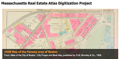
The archive offers numerous editions of the state atlas, as well as country-specific editions. There are numerous maps available for cities and larger towns separate from the state and county atlases, multiple editions of which are available only in some cases (Boston, of course, has many).
While old maps are interesting on their own, they provide an excellent entry point for studies of local history. The state department of education includes local history in their frameworks for third grade social studies, but local history is a topic that can be learned about at varying depths by students of all ages. Younger students may learn basic map skills by comparing new and old maps of their communities, while older students may do more critical assessments of the changes and developments in their city or town by piecing together multiple maps with photos and other sources of information. Students could learn about the history of the state, too – a look at the number of major roads criss-crossing the state today versus the number in 1950 or 1900 says a lot about the changes that society has undergone in the last century. Identifying changes on a local or state level can help to highlight the effects of technology like electricity, telephones, and, most importantly, cars and trucks.
To support map-driven studies with kids, try one (or all!) of these titles:
- Follow That Map!: A First Book of Mapping Skills by Scott Ritchie
- Mapping Penny’s World by Loreen Leedy
- Me on the Map by Joan Sweeney
- Mapmaking with Children: Sense of Place Education for the Elementary Years by David Sobel (book for parents about children’s development and sense of place through mapmaking)


Cool! Sadly, no Hatfield maps yet, other than as part of the 1873 Beers map of Hampshire County.